
Scribble Maps Blog
Know Your Ground: Farming, Site Analysis and Flood Kits
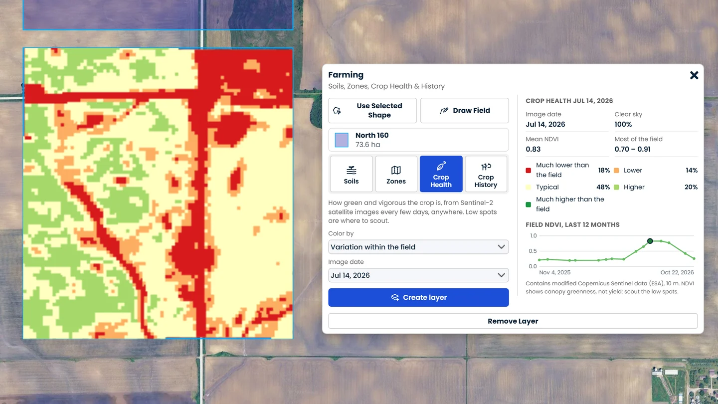
A farmer wants to know which part of a field holds water, which part always lags, and how to seed each one. A builder wants to know how steep a lot is, how much dirt it takes to level it, where the water goes in a storm, and whether the soil can take a septic field. A planner wants to know what goes under water when the river rises. The answers are in soil surveys, satellite images and lidar. But putting them together has usually meant expensive software, a GIS analyst, or a consultant.
Today three kits bring that work into Scribble Maps. Draw a field, a site or an area, pick a tool, and the answer lands on your map in seconds.
Farming: soils, crop health and zones for any field
The Farming kit tells you about one field at a time, anywhere in the world.
- Soils. In the US, see every soil in the field from the USDA soil survey, rated for crop productivity, water-holding capacity and drainage, with prime farmland and wet soils marked. Everywhere else, see the topsoil's texture, organic carbon, pH and CEC from the SoilGrids world soil map.
- Crop health. See how green and vigorous the crop is from Sentinel-2 satellite images, taken every few days, with clouds removed. Color the field by crop vigour, or by how each spot compares with the rest of the field, so weak spots stand out at any time in the season. A 12-month chart shows the field grow, peak and dry down.
- Management zones. Split the field into 2 to 6 zones for variable-rate seeding and fertilizer, from soil ratings or from three seasons of satellite crop vigour. Export them as a shapefile for John Deere Operations Center, Climate FieldView, Trimble and other farm software.
- Crop history. For US fields, see what was planted each year since 2016, with a crop map of any season.
Site Analysis: read the land before you build
Site Analysis now covers both the shape of the land and what it means for building.
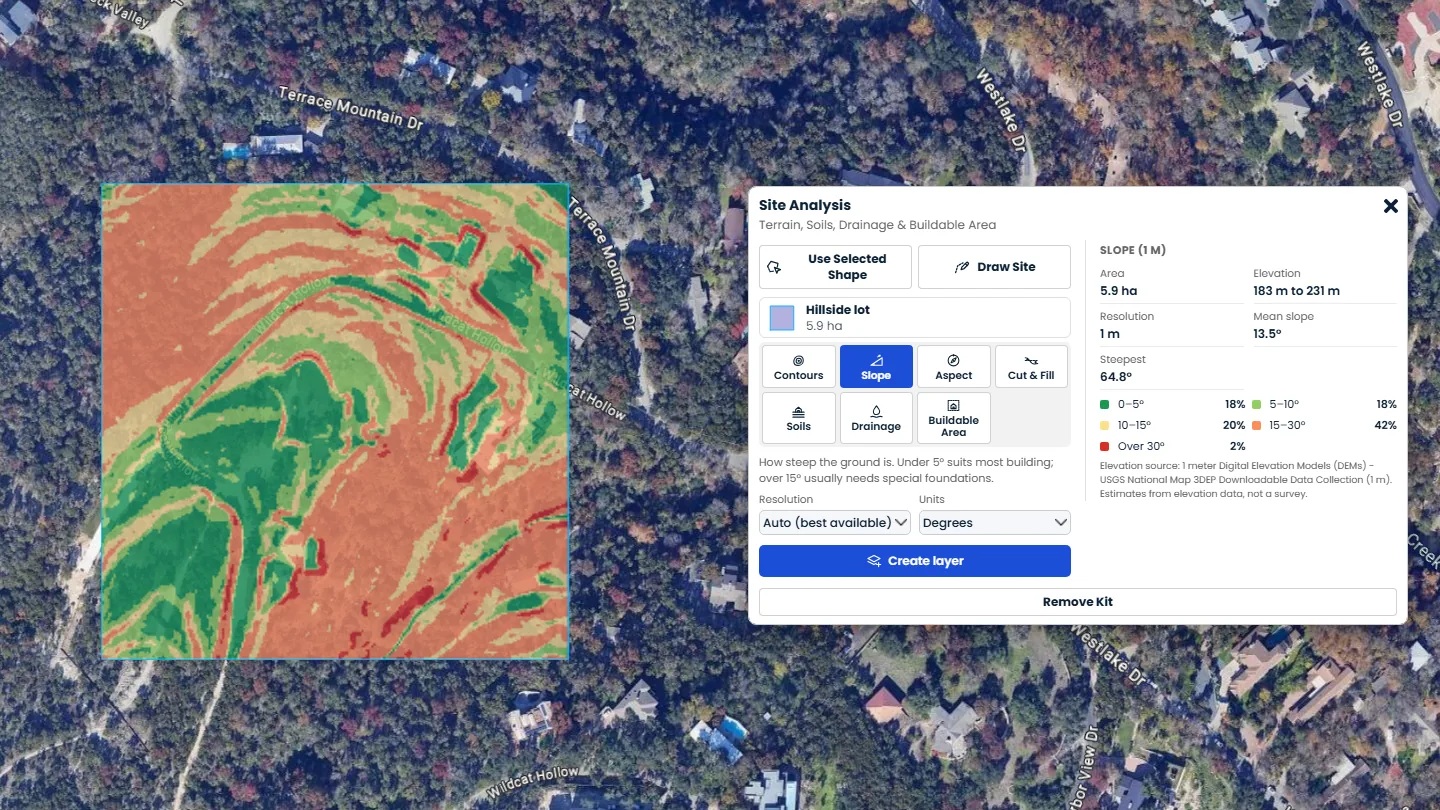
- Terrain. Contour lines, slope and aspect maps, and cut and fill volumes to level a pad, from 1 m lidar across most of the US.
- Soils. Every soil on the site rated Not limited, Somewhat limited or Very limited for houses with or without basements, septic fields, shallow excavations, or local roads (US).
- Drainage. Flow paths, the points where water leaves the site, low spots where it stands, and how much runs off in the storm you choose.
- Buildable area. The ground left to build on after steep slopes, a setback from the boundary, flooding and poor soils, with each buildable area outlined.
Flood: see what floods before it happens
The Flood kit raises the water over the real terrain and shows what goes under, live, as you move a slider.
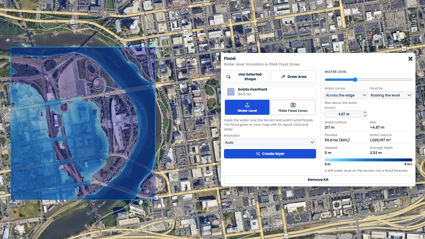
- Water level. Bring the water in across the edge of the area, as a river in flood or the sea would, start it at the lowest ground, or release it at a marker you pick, such as a breach or a burst water main. Raise the level, or set how much water is released and watch it spread over lower ground. The flooded area, the volume and the depth change as you drag. Only ground the water can reach floods, so a levee in the terrain holds until the water goes over it.
- On your map right away. Each run goes on your map with a report card that has its own slider, so you can keep exploring with the kit closed. Save the map to keep the water as it is.
- FEMA flood zones. For US areas, see FEMA's floodways, 100-year and 500-year floodplains, coastal high hazard zones and levee areas, with base flood elevations. One click then sets the water to the base flood elevation, so you can see the 100-year flood on the terrain.
An area can be up to 25,000 acres, enough for a whole neighbourhood or a stretch of river.
Powerful data for everyone
Our mission at Scribble Maps is to make mapping accessible, and to give everyday businesses and individuals the same powerful data that used to be reserved for organizations with big budgets. A family farm deserves the same field insight as a large agribusiness. A small builder deserves the same site check as a big developer. A small town deserves the same flood picture as a big city.
That is why all three kits are included in Pro Business, alongside every other Scribble Maps kit. And every account gets 3 free runs of each kit to try them.
Where the data comes from
We keep our own copies of the USDA soil survey (SSURGO), the USDA Cropland Data Layer and the SoilGrids world soil map, so reports come back fast. Crop health reads the Sentinel-2 archive from the Copernicus program. Elevation is USGS 3DEP lidar across most of the US and 10 to 30 m data elsewhere. Flood zones come from the FEMA National Flood Hazard Layer. Every result names its source on your map.
These are planning tools. Soil ratings, satellite vigour and flood levels are estimates, not a soil test, a yield map, a survey or a flood forecast, and FEMA zones shown here are not an official flood zone determination. Use them to decide where to look, and check what matters on the ground.
Who it is for
- Farmers and ranchers: know each field's soils, spot weak areas early, and make zones for your planter and sprayer.
- Agronomists and crop consultants: build field reports and zone maps for growers in minutes, in any country.
- Builders and developers: check a lot's slope, soils, drainage and flood risk before you bid or buy.
- Land and real estate professionals: show buyers what a parcel can and cannot be used for, and whether it sits in a flood zone.
- Engineers and planners: get a fast first look at grading, runoff, buildable area and flooding before the survey.
- Emergency managers and insurers: see what a river rise, a sea level rise or a breach would flood, next to the FEMA zones.
Try it
Open the Launch Pad or Maps & Data, find Farming, Site Analysis or Flood, and click Use Kit. Pick a shape on your map or draw one, then choose a tool. You can also ask Scribble AI: "make 3 zones for this field for corn", "where does water drain on this site?" or "raise the water 2 metres over this area".
Not on Pro Business yet? Use your 3 free runs of each kit, or see the plans.
For full walkthroughs, read Farming - Soils, Management Zones, Crop Health and Crop History, Site Analysis - Terrain, Soils, Drainage and Buildable Area and Flood - Water Level Simulation and FEMA Flood Zones in the help center.