Route optimization also known as the travelling sales person problem (TSP) is a type of routing to figure out which order you should visit locations in the fastest time possible. As you can imagine this is very useful if you need to drop off packages, do movie location scouting, make sales calls to a physical location, or need to do routine inspections. Well we are happy to announce that this functionality has now come to Scribble Maps. For demonstration purpose we have selected a bunch of different cafes in the Toronto region. Let's pretend that in the course of a day or multiple days you want to visit all of them. Here is a picture of the original points. Unoptimized Points From here we going to go to our Operations & Analysis panel and select Create > Optimized Route. Next you will want to select your start location, end location, and the way points folder that contains the points in your route. After clicking "Create Optimized Route" your ...
Scribble maps has partnered with Skywatch to bring satellite imagery and satellite tasking to Scribble Maps. SkyWatch grants access to over 400 satellites, offering critical data for industries such as agriculture, urban planning, and environmental conservation. Scribble Maps simplifies geographic visualization, making powerful mapping tools accessible to a wide range of users. A standout feature of this partnership is the Automatic Polygon Minimum Area Compliance (APMAC) system, a patent-pending innovation that allows users to order satellite imagery without being restricted by minimum area requirements. This system automatically adjusts the user's selected area to meet provider-imposed minimums, streamlining the purchasing process and improving the user experience. In addition to APMAC, users can now perform advanced band analysis directly within Scribble Maps. This includes: NDVI (Normalized Difference Vegetation Index): Monitor vegetation health and growth. NDWI (Normalized ...
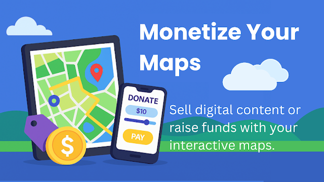
Still sharing your maps in a Google Drive folder? Scribble Maps now lets you turn them into paid digital products — no plugins, no code, just income. Whether you're an outdoor guide, educator, activist, or solo traveller, your map isn’t just a tool—it’s a story. And now, it can be a source of income, support, or community impact. With Sell & Fundraise , Scribble Maps lets you turn your interactive maps into fundraising pages, product storefronts, or premium content hubs —with no extra plugins or platforms. 🔥 Map Monetization Features What is Sell & Fundraise? Sell & Fundraise is Scribble Maps’ built-in monetization feature. With secure Stripe integration and no technical setup required, you can: Sell access to your maps (one-time, subscription, or pay-what-you-want) Accept donations for causes tied to specific locations Add branded payment forms directly inside your map Ideal for: 📦 Creators: Sell neighbourhood guides or digital trail maps 🎓 Educators: D...


.png)
Comments
Post a Comment
Comments are moderated, thanks for your patience.