From Paper to Pixels: The Process of Digitizing Maps
What does it mean to digitize a map?
The process of digitizing a map involves far more than just updating old paper maps and bringing them into the digital age. Instead, it's a complex process that consists of converting the data and geographic features from a paper map into a digital format using GIS software.
When a paper map is digitized, it undergoes a transformation that involves the creation of layers of new data that can be used to enhance pre-existing information. By digitizing an old paper map, you can unlock an array of tools and features offered by platforms such as Scribble Maps, which can help you take your maps to the next level.
The process of digitization starts by scanning the original paper map, creating a high-quality digital image of the original. The digital image can then be analyzed and processed to identify and extract the different geographic features and data represented on the paper map. This information can be used to create new data layers that can be superimposed on the original map.
Once the map has been digitized, you can take advantage of the various tools and features available with Scribble Maps to create custom maps, add annotations and markers, and highlight specific geographic features. You can also use the map to generate various map layers and store data that can be accessed and analyzed with ease.
Why digitize maps?
Overall, digitizing a map is a highly beneficial process that can help you unlock the mysteries and full potential of your old paper maps. It allows you to create customized maps, add new data layers, and access a wide range of tools and features to enhance the functionality of your maps. Whether you are a business owner looking to optimize your logistics operations or an outdoor enthusiast seeking to explore a new trail, digitizing your maps can help you achieve your goals with greater ease and efficiency.• record and display geographic information
• generate map layer
• store data
• and more.
How to digitize maps in Scribble Maps
Digitizing maps can be a helpful task in various fields, including urban planning, surveying, and historical research. Whether you're looking to digitize old maps for historical purposes or simply want to convert hand-drawn maps into a digital format, with the help of Scribble Maps, this process can be easy and efficient. Here are the steps to digitize maps in Scribble Maps.- Step 1: Upload the map image
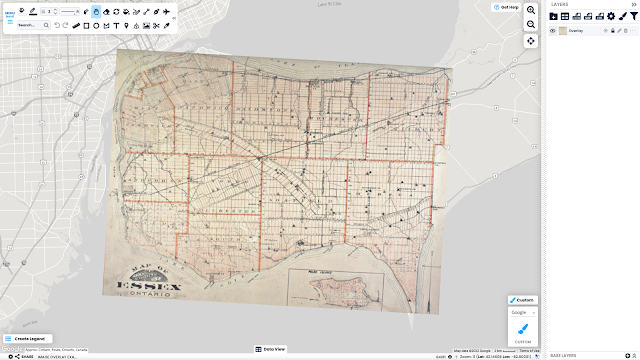
The first step is to upload the map image to Scribble Maps by scanning the image and saving it as a file on your computer. Then, create a new map on the Scribble Maps website and add the image as an overlay. - Step 2: Adjust the opacity
To see through the overlay, adjust its opacity. This will enable you to align the overlay with the map underneath it. - Step 3: Align the overlay with the map
With the overlay adjusted, use the Zoom and Edit/Measure Tool to position it over the corresponding area of the map. You may need to adjust the opacity further to ensure precise alignment. - Step 4: Trace over the map
Using Scribble Maps' tools, trace over the overlay to create a digital version of the map. Begin with the most prominent features, such as roads and rivers, and work your way to smaller details. Use different colours and line thicknesses to distinguish between features. - Step 5: Save your digitized map
When you're finished tracing over the map, save your work. Download the digital version of the map as a file, share it with others, or continue to edit and refine it in Scribble Maps.
Use Case Study
One of the key benefits of the services provided by Pinnacle Pipeline Inspection is the accuracy of their information. The safety of workers and the public is a top priority in the construction industry, and having accurate information about the location of underground facilities is essential for avoiding accidents and ensuring the smooth progress of construction projects. By using the latest technology and tools provided by Scribble Maps, Pinnacle Pipeline Inspection can provide highly accurate maps of underground infrastructure, helping construction crews to avoid potential hazards and work more efficiently.
By offering accurate and reliable information about underground infrastructure, Pinnacle Pipeline Inspection helps to ensure the safety of workers and the public, while also supporting the sustainable development of California's infrastructure.


