
📣 Now Live: Scribble Maps + Google Drive™ Integration

Your mapping workflow just levelled up.
We’re thrilled to announce that Scribble Maps is now officially integrated with Google Drive, available in the Google Workspace Marketplace.
That means no more toggling between tools, manually uploading files, or worrying about version control. You can now open, edit, and collaborate on your mapping files directly from Google Drive. Whether you're working with GeoJSON, KML, SHP, GPKG, CSV, or GPX, Scribble Maps handles it instantly.
🗺️ Why This Matters
For planners, field teams, educators, and analysts alike, this integration is a game-changer. Scribble Maps is built for real work, not just visualizations.
Now, that work happens right where your data lives.
-
Open geospatial files directly from Drive—no downloads required
-
Edit on desktop or mobile, instantly
-
Collaborate in real-time with your team using familiar Google tools
-
Perform advanced tasks like buffer zones, polygon editing, filtering, and spatial analysis, with zero GIS setup
Whether you’re sketching site plans, analyzing impact zones, or mapping wildlife migration, your entire workflow just got faster, easier, and smarter.
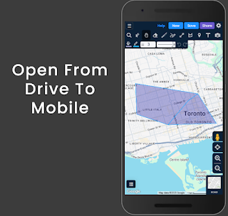 📲 Mobile-Friendly, Team-Ready

Open your Drive files right into Scribble Maps Lite on your phone or tablet while on-site, then refine and collaborate from your desktop later. It’s the best of both worlds, connected through your cloud.
This isn’t just integration—it’s a seamless extension of the way modern teams work.
🔐 Built-In Security & Flexibility
Every map can be saved in Drive, encrypted for privacy, and shared using Drive’s permissions. You stay in control, without having to export or re-upload.
🚀 Get Started in Seconds
Install Scribble Maps from the Google Workspace Marketplace and start working with your spatial data immediately—no onboarding, no friction, no problem.
Scribble Maps + Google Drive™
Mapping where it matters—right inside your workflow.


.png)
Comments
Post a Comment
Comments are moderated, thanks for your patience.