Posts

Showing posts from 2023

Charting Success: Visualizing Data with Precision in GIS

Image
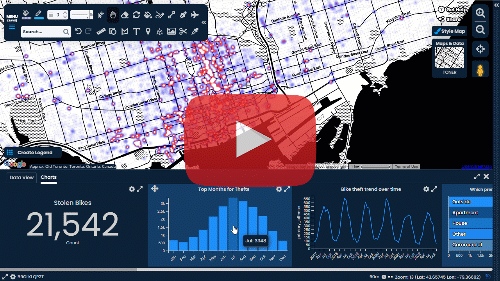
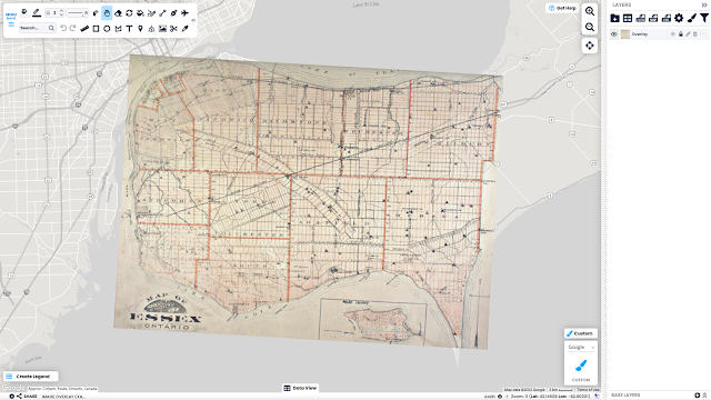
Geographic Information System (GIS) is your compass in the world of spatial data, guiding you through the intricacies of managing, analyzing, and visualizing data. But there's a whole new landscape to explore beyond maps. Chart View, a dynamic new feature within Scribble Maps, adds depth and context to your data analysis, bringing patterns and trends to life. Chart View adds a crucial element in GIS software that revolutionizes data understanding and decision-making and empowers users to gain deeper insights and make data-driven decisions across various fields. Harnessing the Power of Chart View in GIS Charts are the unsung heroes of data analysis that simplify complex geographic information. They have the unique ability to transform raw data into clear and comprehensible graphics, making it easier to spot trends, patterns, and essential insights. Whether you're unravelling population distributions, optimizing resource allocations, or tracking changes over time, charts play a p...

The Beauty and Functionality of Pattern Fill

Image
A Guide to Creating Engaging and Accessible Visualizations Have you ever found yourself lost in the intricate beauty of a map, pondering over the wealth of information it holds? Creating a map that is both informative and engaging can be a daunting task. Fortunately, there are ways to make the process more manageable. One of them is pattern fill, a design tool that uses repeating visual designs or textures to add interest, texture, and context to map elements. By employing pattern fill, you can enhance both the aesthetics and inclusivity of your map, making it more accessible to a wider audience. What is Pattern Fill? Pattern Fill is a popular graphic design technique that refers to a repeating visual design or texture applied to a shape or area. The pattern can range from a simple design, such as a series of parallel lines or dots, to a more complex design, such as a repeating graphic element, photograph, or abstract artwork. The basic feature of pattern fill is that it seamlessly rep...

From Paper to Pixels: The Process of Digitizing Maps

Image
What does it mean to digitize a map? The process of digitizing a map involves far more than just updating old paper maps and bringing them into the digital age. Instead, it's a complex process that consists of converting the data and geographic features from a paper map into a digital format using GIS software. When a paper map is digitized, it undergoes a transformation that involves the creation of layers of new data that can be used to enhance pre-existing information. By digitizing an old paper map, you can unlock an array of tools and features offered by platforms such as Scribble Maps, which can help you take your maps to the next level. The process of digitization starts by scanning the original paper map, creating a high-quality digital image of the original. The digital image can then be analyzed and processed to identify and extract the different geographic features and data represented on the paper map. This information can be used to create new data layers that can be s...

Fuel to the Scribble Maps' Fire

Image
The Power of User Feedback Have you ever wondered what separates ordinary products from the extraordinary? The answer lies in you—the user. In today's rapidly evolving landscape of digital innovation, user feedback has become an invaluable asset for companies that plays a crucial role in their success, empowering them to develop products that align with customer needs. At Scribble Maps, we have wholeheartedly embraced this truth, transforming user insights into innovative features to enhance user experiences. Incorporating user feedback has become a powerful catalyst for innovation and enhancing user experience. "You asked for it, we built it!" has become the driving force behind our journey to success. Empowering User Voices Since its inception, the Scribble Maps journey has been defined by continuous improvement, and your feedback is at the heart of it all. We actively listen to our users, valuing your insights and taking your feedback seriously. By incorporating your i...

Introducing Fractional Zoom

Image
Redefining Precision and Detail with the Image Generator In the ever-evolving world of cartography, where maps are the compasses guiding us through uncharted territories, precision and detail serve as the North Star. We are excited to introduce our new Fractional Zoom feature, available exclusively through the Image Generator. With Fractional Zoom, you can now take your images and PDFs to incredible precision and detail, bringing your visions to life like never before. What is the Image Generator? The Image Generator in Scribble Maps empowers you to customize and save your map printouts effortlessly. Experience the flexibility to create stunning images and PDFs that perfectly capture the essence of your maps. Whether for complex cartographic projects or creating travel posters, the Image Generator offers a range of powerful options to enhance your map outputs. With the Image Generator, you can: Save your map : Conveniently save your maps for further customization and exploration. Gener...

GIS Meets Fantasy — World Generator by Scribble Maps

Image
Fantasy maps have always been an integral part of the fantasy genre, providing a visual representation of the imaginary world in which the story is set in. These maps are often used to help readers navigate the world and understand the geography and political boundaries of the various kingdoms, cities, and other locations of the wider story. One of the most iconic examples of this is J.R.R. Tolkien’s map of Middle-earth, featured in his The Lord of the Rings trilogy. The map was created by Tolkien himself, which he used to keep track of the various locations and characters in his story. His map was also included in the first edition of The Lord of the Rings, giving readers a glimpse into the epic world of Middle-earth. Another famous fantasy map is the one from George R.R. Martin’s A Song of Ice and Fire series, which was prominently used in the opening credits of the popular series Game of Thrones. In video games, fantasy maps serve a vital role in immersing players into the captivati...