Posts

Showing posts from 2021

The Mapping Swiss Army Knife Of Real Estate

Image
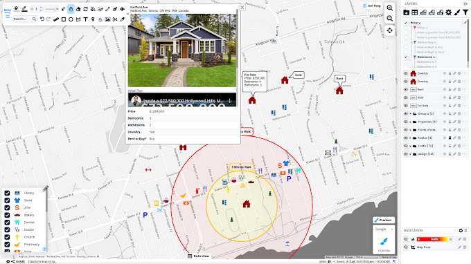
Knowledge is power! So why not have as much of it as possible. The more data you can collect, the more informed your decisions can be. But what do you do with all that data once you have it? Now you have stacks and stacks of information, how do you make sense of it all? Using our online map maker we make it easy. Here Are 5 ways you can use Scribble Maps for Real Estate: 1. Transform your Spreadsheets into Maps Tell the story of your data through visual representation. Most people would rather watch a movie than read the script. Use Scribble Maps to import your XLS, CVS and other spreadsheets to bring your spreadsheets to life and help illustrate the full story. Data is dull; maps are memorable! 2. Data filtering Once you have imported your spreadsheets, use our data filtering tools to efficiently sort through information. Data filtering helps show data that you want to see based on specific conditions. It allows you to quickly filter spreadsheets such as XLS, CVS, or custom attribute

How to make a custom map

Image
There are many reasons why someone wants to create a map, but using the Scribble Maps online map editor , you can quickly make your own custom map where only your imagination is the limit. It would be impossible to go over every type of map you can create with Scribble Maps, but we will cover some in this post. If you want to hop in as quickly as possible, you can watch our first map video, which will go over all the basic tools you need to get started with Scribble Maps. Select or style the base map One of the first things you will want to do is set the base map or customize the existing one. For instance, creating a custom map style, such as a map without labels, click the custom bottom in the bottom right. Now you can turn off options like labels. Add drawings and markers to your map some of the most common things you may want to do are add drawings, markers, or text to your map. To accomplish this, all you need to do is select the tool you want in the toolbar and then click or drag

Create Service Area Polygons (Voronoi Diagrams)

Image
  In 1854 physician John Snow used Voronoi-like diagrams to figure out an infected water pump in London. However, a less dark use case of Voronoi diagrams is simply figuring out service areas, also known as catchment areas, for things like schools, stores, and hospitals. Simply, a service area polygon shows what point is closest to you. We have no brought the ability to create these types of maps to Scribble Maps! To create a Voronoi diagram follow these steps. Step 1 Create some markers and put them inside of a folder. Step 2 Open operations and analysis and click "Service Areas." Step 3 Select the folder and click "Create Polygons." Optionally, you can click the checkbox for random colours.  That's it! You can now start doing other things like moving polygons, changing styles, or doing further analysis. We hope you enjoy this new feature!

Create Island Polygons (Donut Holes) and Merge Polygons

Image
In the world there are a lot of situations where you have shapes with holes in them. The one that stands out as a very common one is the pentagon. However, there is a lot of other situations where you might want a hole in a polygon such as a polygon representing all the water around an island. In Scribble Maps you can easily create polygons with holes and then even use these polygons to filter your existing layers. Let's imagine you wanted all the points that are inside of a particular ring, you could do this using a polygon with holes. The other advantage of using holes in polygons is you can create sequential rings that will all have the same opacity which is particularly useful if you are trying to make a delivery fee map. In this post we are going to go over quickly how to make a hole in a polygon and also go over some use cases. We will also be talking about merging polygons  because this often goes hand in hand with creating polygons with holes. Creating Donut Holes To cut a

Travel Time Polygon Enhancement

Image
We have added two new styles hex tile and square tile to the travel polygon functionality. We have also added the ability to create travel polygon based on distance. If you are familiar with this operation, you can hop right in. If you are new to Scribble Maps, read on for an explanation of how to create your own travel polygon. There are different names for it including isochrone maps, travel time polygons, and drive time radius but regardless of the name it serves the same purpose. It's a shape that identifies areas with a shared attribute such as what is within a ten minute walk or drive. With Scribble Maps we allow you to make these travel polygons easily. We have two different modes one for time, and one for distance. Time is useful when you want to be able to figure out what is within a certain travel time of a particular point. Distance allows you to figure out how much distance is travelled which is useful for things like insurance. To create a travel time polygon or drive